wordless wednesday

a
b

Thanks for stopping by, Chris

Follow me on Instagram https://instagram.com/ccphotographyai

Facebook CC Photography of Amelia

Flickr Chasing Classic Cameras with Chris

Comments are always welcome; I’ve learned a great deal from reader feedback. As always, thanks for stopping by. While there, visit my camera shop at http://www.ccstudio2380.com (CC Design Studios, hosted on Etsy). – Chris Whelan

Please respect that all content, including photos and text, is the property of this blog and its owner, Yashica Pentamatic Fanatic, Yashica Sailor Boy, Yashica Chris, and Chasing Classic Cameras with Chris. Copyright © 2015-2026 Chasing Classic Cameras with Chris (Yashica Pentamatic Fanatic), Chris Whelan. All rights reserved.
Amazing hurricane – but not in a good way!

storm 9-2

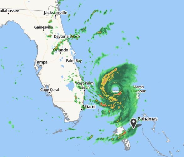
Radar image out of Nassau, Bahamas at approximately 11 AM Sep 2. The eye of Hurricane Dorian continues to spin just over the central coast of Grand Bahama Island.

I’ve been a professional meteorologist since 1975 and while in the US Navy serving on various ships over twenty-two years I’ve encountered my share of strong hurricanes and typhoons. I’ve tracked and made forecasts for hundreds of tropical systems and have seen first hand just how powerful they are and the destruction they cause. I’ve experienced a few hurricanes that have gone stationary before but this one, Hurricane Dorian is amazing to me for just how long it’s been nearly stationary over the central part of Grand Bahama Island while maintaining its Cat 5 status (now downgraded to Cat 4) as of this post.

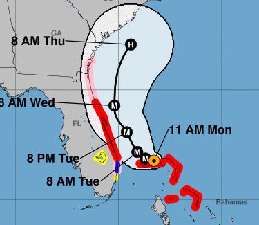
This is the latest forecast from the NWS National Hurricane Center as of 11 AM on September 2, 2019. Optimistically the forecast track shows Dorian well northwest of its present location in less than 22 hours and by Tuesday morning at 8 AM it could be about 60 to 80 miles further north-northwest from where it is now. The hope is that a broad trough of low pressure now over the central US will start to influence the storm and take it away from a direct strike on the east coast of Florida over the next 2 to 3 days.

track

Official position and forecast track of Hurricane Dorian from the National Hurricane Center in Miami, Florida. 11 AM Sep 2.

I would like to see some slight movement of the center to the north or northwest over the next few hours for the forecast track to verify. Here’s hoping!

Chris