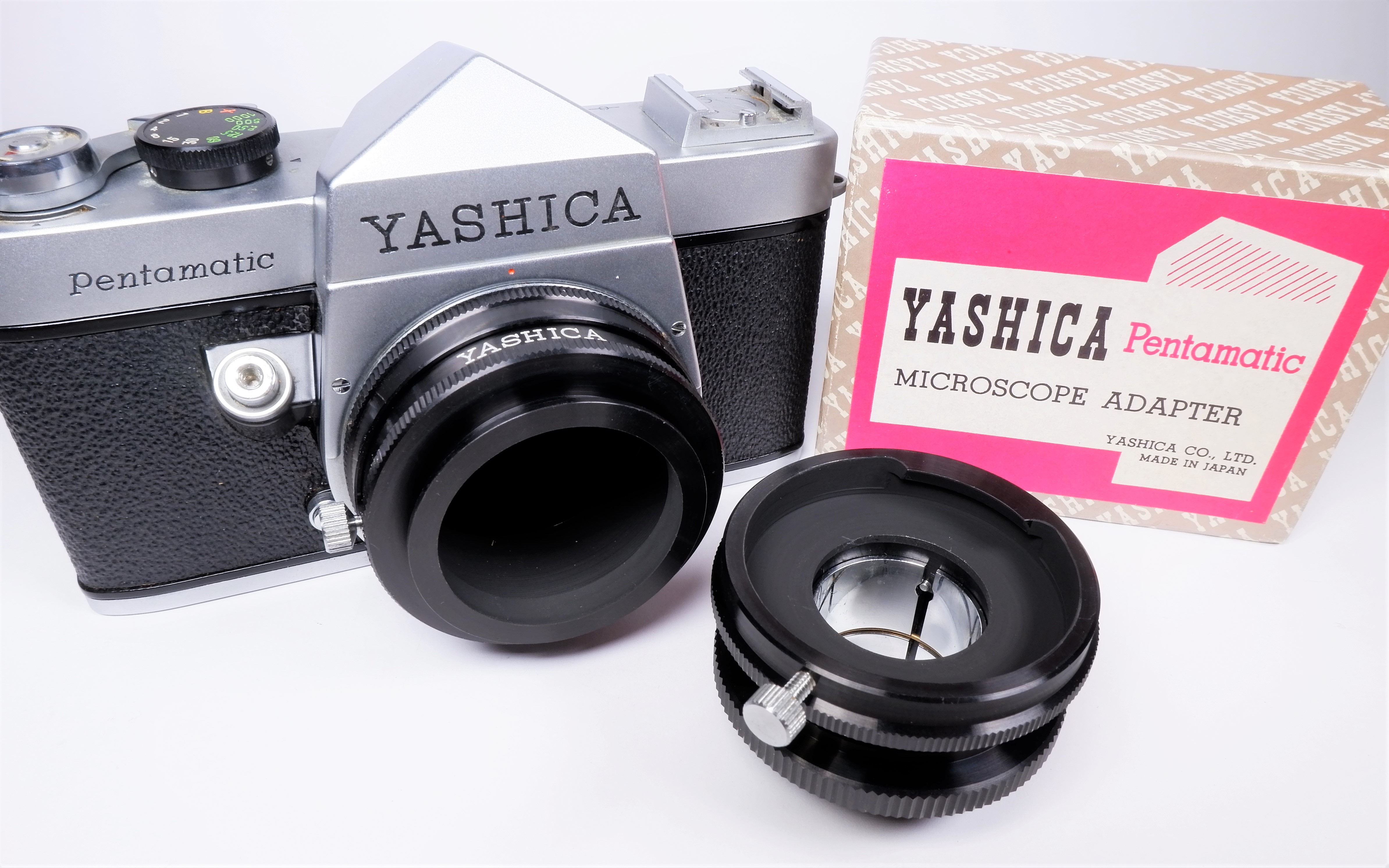
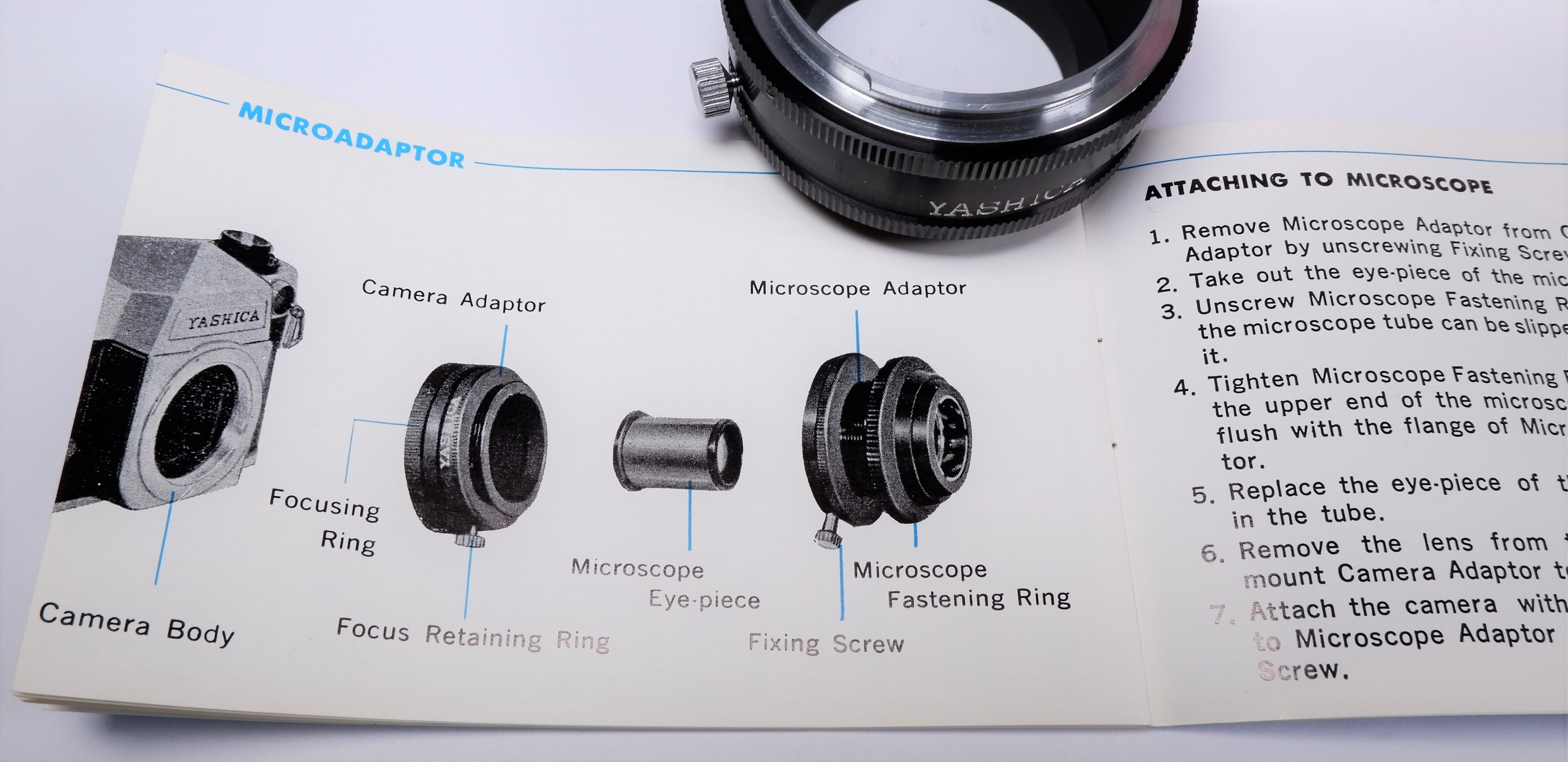
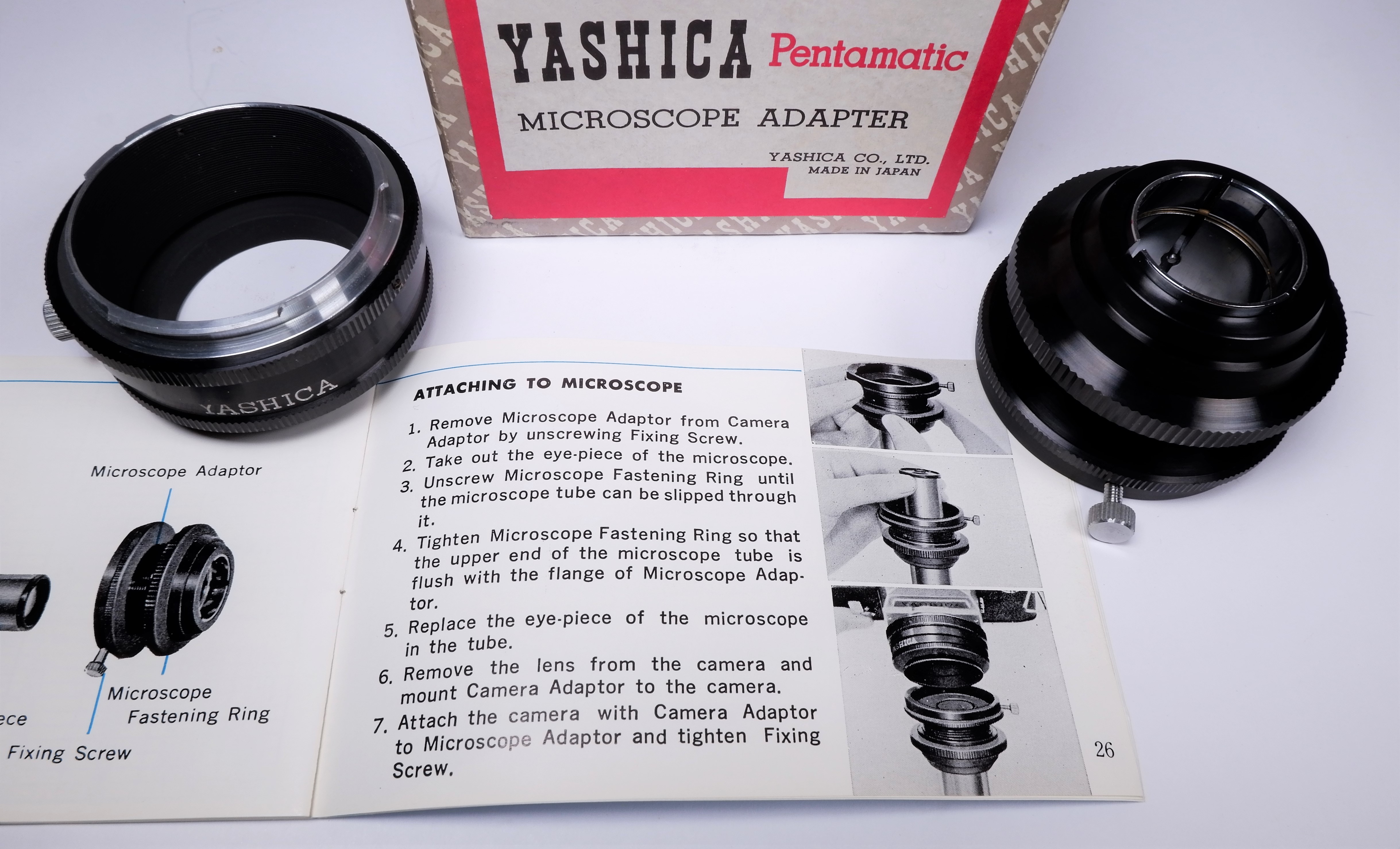
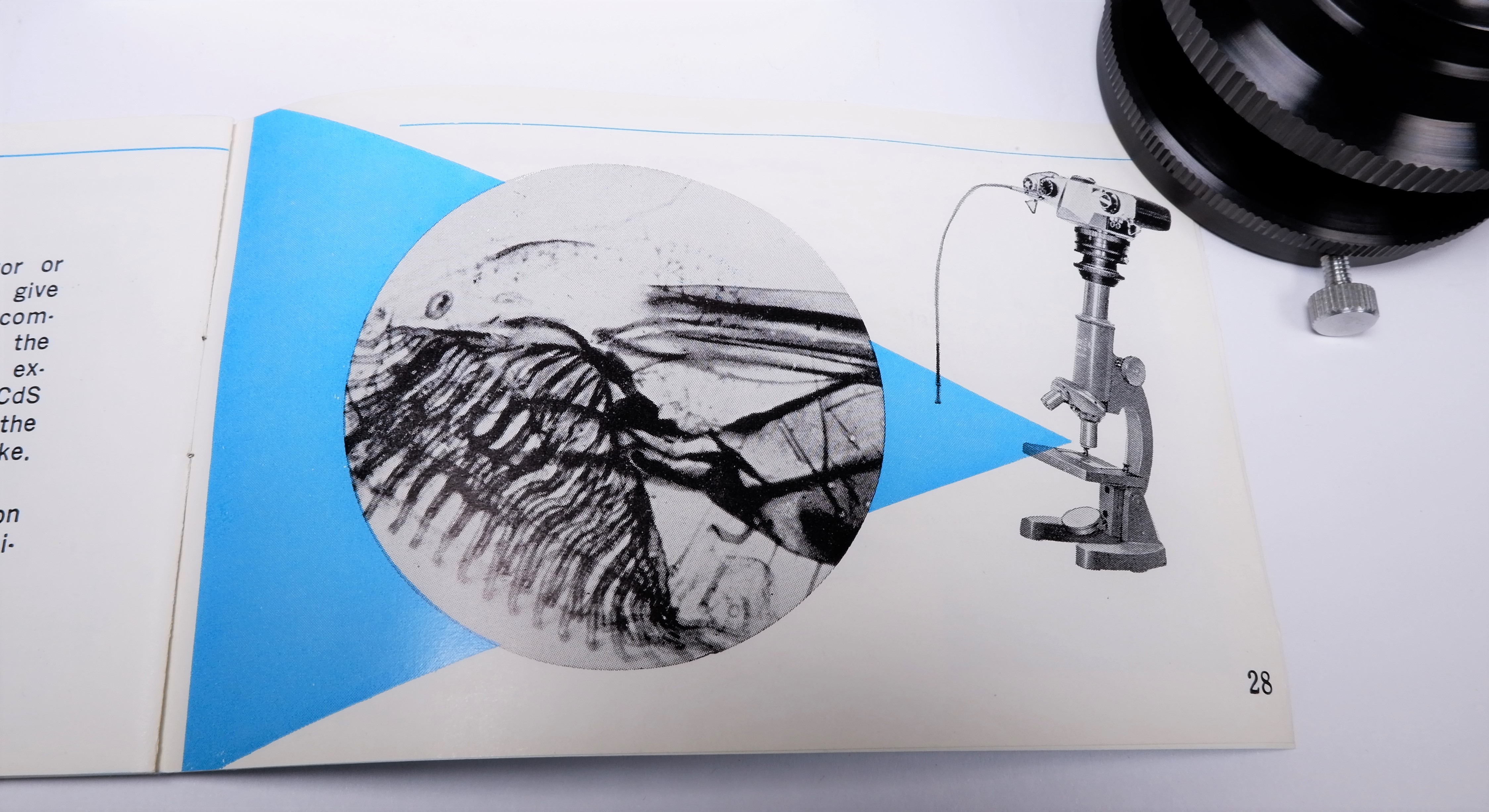
The advantages of being a self-diagnosed hypochondriac during a pandemic…

None that I can think of at the moment. Here’s a funny post that describes me to a tee… well, almost.

snip hypo

Stay at home and self-quarantine – that’s a normal day for me. Wash your hands frequently – how many times beyond fifty a day is considered excessive?

lucy peanuts

Isolation can be a desperate time for many – call friends frequently and check on the family.

All kidding aside, please take care of yourselves and remember to check frequently on family and friends – during stressful times like this, a person’s mental wellness is important too.

Have a wonderful day and stay safe! – Chris

Friday Fotos! – Florida “Whine”

20200221_153707

Today’s high temperature. At least the sun is out but it’s also very windy. Better days ahead.

Thanks for stopping by for a bit of my Florida “whine”. – Chris

Please respect that all content, including photos and text, are the property of this blog and its owner, Yashica Pentamatic Fanatic, Yashica Sailor Boy, Yashica Chris.

Copyright © 2015-2020 Yashica Pentamatic Fanatic, Chris Whelan
All rights reserved.

Hurricane Dorian – Sep 4, 2019, 1:30 PM Update

snip 9-4 1

As of the 1:30 PM radar update, Hurricane Dorian’s center is now just south of due east of Amelia Island and some of the strongest outer bands of precipitation are now just approaching our coastline. The yellow and red areas on the radar more than likely contain 40-50 mph sustained winds with gusts to 65+. This dance between the northward movement of the storm and the movement of these outer bands will be a close call for us.

Power is still on ATM!

Chris

Hurricane Dorian – Sep 4, 2019

Here’s the lastest snip of the hurricane as seen on enhanced radar. The eye is quite large and the eyewall has maintained its ragged appearance since yesterday. The central pressure is up to 964 mb and the sustained winds are down a bit. The eye will past well east of our island but I’m afraid that we’ll catch the outer squalls from the storm… soon.

snip 9-4

Radar view as of 9 AM this morning. The western edge of the strongest convection and winds are now just about 30 or so miles east of Amelia Island. It’s going to be a close brush with the squalls associated with the outer edge of the storm (the yellow and red areas).

I thought I would post a bit earlier today since there’s a real possibility that we may lose power within the next couple of hours. The last time we lost power was for 61 hours with the passage of Hurricane Irma well west of us in 2017. Hopefully nothing like that this time.

You can see my post from yesterday here.

Chris

Hurricane Dorian – Sep 3, 2019

An update on Hurricane Dorian as of 11 AM

snip 9-3

Radar image from Nassau, Bahamas as of 11 AM Tuesday, September 3rd.

Some changes noted since 11 AM yesterday. The eye has expanded but has become a bit ragged as dry air from over Florida has disrupted the appearance of the western eyewall. The precipitation areas have expanded northward and of course, the southern edge of the eye is now north of Grand Bahama Island (barely). The hurricane has also weakened quite a bit from 24 hours ago with the central pressure now at 955 mb up from a low of 910 mb at the height of the storm’s intensity.

Compared to yesterday’s scan of the radar (see below) the changes are obvious.

storm 9-2

From the NWS National Hurricane Center the 11 AM prediction of the track of Dorian.

snip map 9-3

Today as of 11 AM

track

Yesterday as of 11 AM

Things are looking better for the east coast of Florida as the accuracy of the short term forecast track improves with time. Hoping for the best but always prepared for the worst.

You can view my post about Dorian from yesterday here.

Chris

Amazing hurricane – but not in a good way!

storm 9-2

Radar image out of Nassau, Bahamas at approximately 11 AM Sep 2. The eye of Hurricane Dorian continues to spin just over the central coast of Grand Bahama Island.

I’ve been a professional meteorologist since 1975 and while in the US Navy serving on various ships over twenty-two years I’ve encountered my share of strong hurricanes and typhoons. I’ve tracked and made forecasts for hundreds of tropical systems and have seen first hand just how powerful they are and the destruction they cause. I’ve experienced a few hurricanes that have gone stationary before but this one, Hurricane Dorian is amazing to me for just how long it’s been nearly stationary over the central part of Grand Bahama Island while maintaining its Cat 5 status (now downgraded to Cat 4) as of this post.

This is the latest forecast from the NWS National Hurricane Center as of 11 AM on September 2, 2019. Optimistically the forecast track shows Dorian well northwest of its present location in less than 22 hours and by Tuesday morning at 8 AM it could be about 60 to 80 miles further north-northwest from where it is now. The hope is that a broad trough of low pressure now over the central US will start to influence the storm and take it away from a direct strike on the east coast of Florida over the next 2 to 3 days.

track

Official position and forecast track of Hurricane Dorian from the National Hurricane Center in Miami, Florida. 11 AM Sep 2.

I would like to see some slight movement of the center to the north or northwest over the next few hours for the forecast track to verify. Here’s hoping!

Chris

The road to success!

After nearly 30 years of service, our residential street is finally being resurfaced. The process is called “chip sealing” (pictured) which will be followed by micro-surfacing.

Early this morning (8.29.19) the work crews got going on the road improvements.

20190829_090810

This truck is laying out the liquid asphalt material just ahead of the chip spreader. The side closest to the camera has already been laid.

20190829_090822

The chip spreader machine moves quite fast – here it’s laying down a uniform layer of gravel chips into the freshly applied asphalt.

20190829_090830

The dump truck is locked onto the spreader machine and is towed backward down the street. I’m thinking that the spreader operator controls the movement of the dump truck.

20190829_090837

Instant results but only half complete at this point. The chip sealed surface is not a desirable one by itself so the streets will be micro-surfaced shortly. That will make for a much more user-friendly surface for bicycles, strollers, people, and cars (less road-noise, smoother surface). All of this is being completed just before the potential arrival of Hurricane Dorian this weekend (see below).

Here’s hoping that the hurricane stays at sea well off the coast of the US (unlikely at this point in time). If it does make landfall on the central east coast of Florida as a Category 3, 4 or 5 that obviously would be catastrophic.

dorian

Thanks for stopping by! – Chris

Pentamatic Microscope Adapter – 1960

I have yet to use a microscope adapter in nearly 50 years of 35mm photography – but that doesn’t mean that I haven’t collected them and enjoyed the thought of someday using one. I’ve had a few Canon adapters over the years too.

The first step would be actively looking for a microscope to purchase on one of the many online auction sites. Something I will do.

Here’s a nice adapter from Yashica with the Pentamatic bayonet mount. It’s one of the first accessories to appear in the early Pentamatic instruction booklets from 1960. List price was ¥2,500 which was fairly expensive back in the day.

DSCF9889

The adapter mounts directly to the body of the camera – no lens needed.

p1 acc page

A scan from an early Pentamatic sales brochure.

DSCF9890

DSCF9893

These instructions are from a later booklet featuring the adapter for the M42 screw mount.

DSCF9892

DSCF9895

I believe that the microscope depicted here is a Yashima microscope but it’s not made by Yashica. Yashima was the first name that Yashica went by in the early 1950s.

d302624294.1

Not made by Yashica but still a super cool vintage microscope.

22533200692_c8120c1a4e_o

Typically you’d use a right angle finder such as this one to make it a bit easier to use the adapter on a microscope.

What’s always amazed me is just how many different camera manufacturers made microscope adapters – Canon, Olympus, Nikon just to name a few and how many are still available for purchase online from various auction sites that are unused, still new in their boxes.

22366435879_1e932f39ba_o

Thanks for stopping by! – Chris

Please respect that all content, including photos and text, are the property of this blog and its owner, Yashica Pentamatic Fanatic, Yashica Sailor Boy, Yashica Chris.

Copyright © 2015-2019 Yashica Pentamatic Fanatic, Chris Whelan
All rights reserved.

Vintage Bewi Automat “A” Exposure Meter

Straight from the desk of a mid-century designer, this super cool (and fully working) selenium cell exposure meter is a joy to use and play with.

DSCF9661

The first thing I noticed about it is that unlike typical meters from this period (the 1950s) there’s no visible meter needle or pointer. Everything that moves does so inside. I know, I took it apart to see what was going on and there was the needle being “busy” reacting to light. Maybe this ad will do a better job at describing just what makes this meter so special.

5035958868_5796574f21_o

DSCF9653

Semi-transparent cover over the selenium cells allows for incident light readings.

DSCF9654

Selenium cells exposed for full reflected light readings.

DSCF9656

In its case, it’s about the size of a deck of cards but it fits nicely in the palm of your hand. I have it available in my shop as it’s time to pass it along to the next collector. You can see additional pictures of it and a complete description at http://www.ccstudio2380.com

Thanks for stopping by! – Chris

Please respect that all content, including photos and text, are the property of this blog and its owner, Yashica Pentamatic Fanatic, Yashica Sailor Boy, Yashica Chris.

Copyright © 2015-2019 Yashica Pentamatic Fanatic, Chris Whelan
All rights reserved.