A warm winter – so far

Here in extreme Northeast Florida (Amelia Island) our winter has been very mild which is following a winter from last year that saw no sub-freezing temperatures or frost. Here it is the second week of January and the trees and plants are showing early spring growth.

20200113_133531

First up are the poor river maples in my front yard. They still have some green leaves from this past summer and leaves that have changed color with the onset of autumn – and now there are blossoms for the next round of leaves. I’ve never seen blossoms this early and certainly, I’ve never seen this many of last season’s leaves still hanging on. I would think that climatologically we’re still capable of having a hard (and damaging) freeze here before February is over.

20200113_133825

Here are our azaleas starting to blossom – about one month too early and indicative of the mild winter we’re experiencing.

DSCF7533

The river maples with plenty of last seasons leaves and the new blossoms starting to pop. A large oak is visible in the background. Typically the oak will shed its leaves during April and May.

At this point in time with so many spring buds and blossoms appearing our hope is to avoid a hard freeze before spring. We hit 76 degrees here along the coast with the mid-80s reported inland.

Thanks for stopping by! – Chris

Please respect that all content, including photos and text, are the property of this blog and its owner, Yashica Pentamatic Fanatic, Yashica Sailor Boy, Yashica Chris.

Copyright © 2015-2020 Yashica Pentamatic Fanatic, Chris Whelan
All rights reserved.

The Bog

20191222_112300

A view from my sunroom window of our backyard habitat. Steady winter rains have reestablished the bog. It’s rained for about 48 hours straight as a low from the Gulf of Mexico moved across the southeast.

Thanks for stopping by! – Chris

Friday Fotos!

20191122_161057

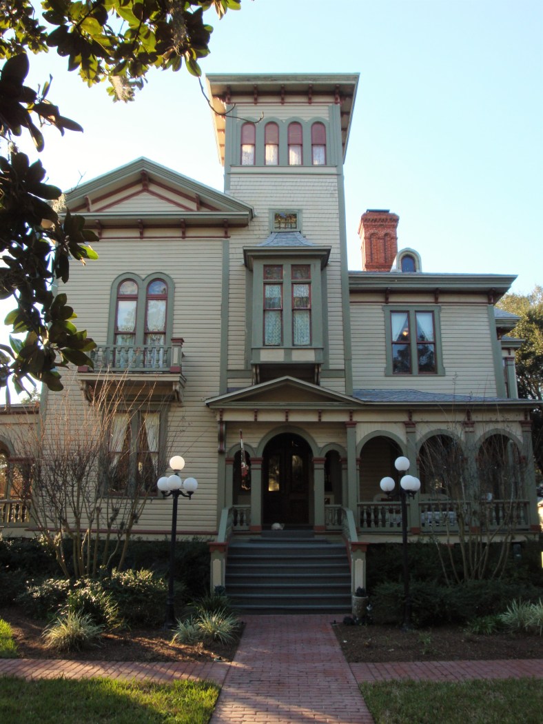
Beautiful carriage house – historic district, Fernandina Beach, Amelia Island, Florida

Thanks for stopping by! – Chris

Please respect that all content, including photos and text, are the property of this blog and its owner, Yashica Pentamatic Fanatic, Yashica Sailor Boy, Yashica Chris.

Copyright © 2015-2019 Yashica Pentamatic Fanatic, Chris Whelan
All rights reserved.

Hurricane Dorian – Sep 4, 2019, 1:30 PM Update

snip 9-4 1

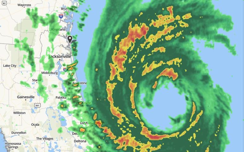
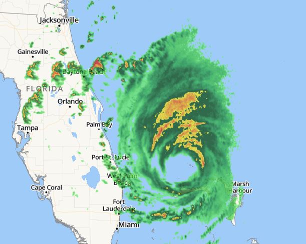
As of the 1:30 PM radar update, Hurricane Dorian’s center is now just south of due east of Amelia Island and some of the strongest outer bands of precipitation are now just approaching our coastline. The yellow and red areas on the radar more than likely contain 40-50 mph sustained winds with gusts to 65+. This dance between the northward movement of the storm and the movement of these outer bands will be a close call for us.

Power is still on ATM!

Chris

Hurricane Dorian – Sep 4, 2019

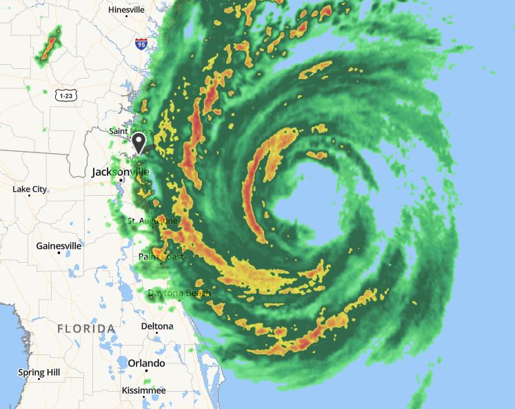
Here’s the lastest snip of the hurricane as seen on enhanced radar. The eye is quite large and the eyewall has maintained its ragged appearance since yesterday. The central pressure is up to 964 mb and the sustained winds are down a bit. The eye will past well east of our island but I’m afraid that we’ll catch the outer squalls from the storm… soon.

snip 9-4

Radar view as of 9 AM this morning. The western edge of the strongest convection and winds are now just about 30 or so miles east of Amelia Island. It’s going to be a close brush with the squalls associated with the outer edge of the storm (the yellow and red areas).

I thought I would post a bit earlier today since there’s a real possibility that we may lose power within the next couple of hours. The last time we lost power was for 61 hours with the passage of Hurricane Irma well west of us in 2017. Hopefully nothing like that this time.

You can see my post from yesterday here.

Chris

Hurricane Dorian – Sep 3, 2019

An update on Hurricane Dorian as of 11 AM

snip 9-3

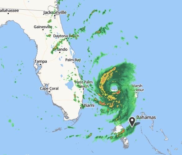
Radar image from Nassau, Bahamas as of 11 AM Tuesday, September 3rd.

Some changes noted since 11 AM yesterday. The eye has expanded but has become a bit ragged as dry air from over Florida has disrupted the appearance of the western eyewall. The precipitation areas have expanded northward and of course, the southern edge of the eye is now north of Grand Bahama Island (barely). The hurricane has also weakened quite a bit from 24 hours ago with the central pressure now at 955 mb up from a low of 910 mb at the height of the storm’s intensity.

Compared to yesterday’s scan of the radar (see below) the changes are obvious.

storm 9-2

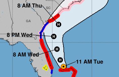
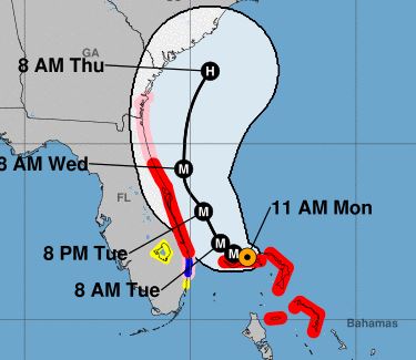
From the NWS National Hurricane Center the 11 AM prediction of the track of Dorian.

snip map 9-3

Today as of 11 AM

track

Yesterday as of 11 AM

Things are looking better for the east coast of Florida as the accuracy of the short term forecast track improves with time. Hoping for the best but always prepared for the worst.

You can view my post about Dorian from yesterday here.

Chris