wordless wednesday

Japan Red Train

Japan Commuter

Thanks for stopping by! – Chris

Canon F-1 on Kodak Kodachrome – Yokohama, Japan – 1979

Please respect that all content, including photos and text, are the property of this blog and its owner, Yashica Pentamatic Fanatic, Yashica Sailor Boy, Yashica Chris.

Copyright © 2015-2019 Yashica Pentamatic Fanatic, Chris Whelan
All rights reserved.

wordless wednesday

15369672917_1942f3eacc_o

Thanks for stopping by! – Chris

Best Pizza – Ever! At Disney’s Epcot. Via Napoli in the Italian Pavilion.

Please respect that all content, including photos and text, are the property of this blog and its owner, Yashica Pentamatic Fanatic, Yashica Sailor Boy, Yashica Chris.

Copyright © 2015-2019 Yashica Pentamatic Fanatic, Chris Whelan
All rights reserved.

Yashica on Broadway 1962

November-December 1962. Yashica billboard in NYC.

Yashica Ad NYC

Yashica Billboard NYC Xclose

Yashica ad from late 1962 features a typical TLR, rangefinder, and SLR popular at that time.

“Yashica Cameras, The World Over”

Yashica Billboard NYC 1

Loew’s State Theatre located at 1540 Broadway, was running the just-released “Mutiny on the Bounty” at the time these photos were taken.

Thanks for stopping by! – Chris


Happy SUNday! – Photography by the pound!

Canon F1 with Montreal

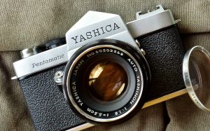
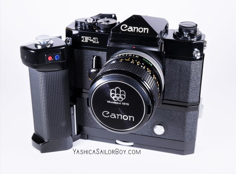
My vintage 1978 Canon F-1. I’ve owned it since new and it’s pretty much traveled the world with me. From Japan to Australia, Hong Kong, South Korea, The Philippines, Thailand, Africa, Europe, Pakistan, Puerto Rico, The Bahamas, the US and most places in between.

4 pounds 6.2 ounces without film and batteries. That’s 1,991 grams of neck cramping weight!

Have a great day and thank goodness for my “tiny” digital cameras! – Chris

Please respect that all content, including photos and text, are the property of this blog and its owner, Yashica Pentamatic Fanatic, Yashica Sailor Boy, Yashica Chris.

Copyright © 2015-2019 Yashica Pentamatic Fanatic, Chris Whelan
All rights reserved.


Hurricane Dorian – Sep 4, 2019, 1:30 PM Update

snip 9-4 1

As of the 1:30 PM radar update, Hurricane Dorian’s center is now just south of due east of Amelia Island and some of the strongest outer bands of precipitation are now just approaching our coastline. The yellow and red areas on the radar more than likely contain 40-50 mph sustained winds with gusts to 65+. This dance between the northward movement of the storm and the movement of these outer bands will be a close call for us.

Power is still on ATM!

Chris

Hurricane Dorian – Sep 4, 2019

Here’s the lastest snip of the hurricane as seen on enhanced radar. The eye is quite large and the eyewall has maintained its ragged appearance since yesterday. The central pressure is up to 964 mb and the sustained winds are down a bit. The eye will past well east of our island but I’m afraid that we’ll catch the outer squalls from the storm… soon.

snip 9-4

Radar view as of 9 AM this morning. The western edge of the strongest convection and winds are now just about 30 or so miles east of Amelia Island. It’s going to be a close brush with the squalls associated with the outer edge of the storm (the yellow and red areas).

I thought I would post a bit earlier today since there’s a real possibility that we may lose power within the next couple of hours. The last time we lost power was for 61 hours with the passage of Hurricane Irma well west of us in 2017. Hopefully nothing like that this time.

You can see my post from yesterday here.

Chris

Hurricane Dorian – Sep 3, 2019

An update on Hurricane Dorian as of 11 AM

snip 9-3

Radar image from Nassau, Bahamas as of 11 AM Tuesday, September 3rd.

Some changes noted since 11 AM yesterday. The eye has expanded but has become a bit ragged as dry air from over Florida has disrupted the appearance of the western eyewall. The precipitation areas have expanded northward and of course, the southern edge of the eye is now north of Grand Bahama Island (barely). The hurricane has also weakened quite a bit from 24 hours ago with the central pressure now at 955 mb up from a low of 910 mb at the height of the storm’s intensity.

Compared to yesterday’s scan of the radar (see below) the changes are obvious.

storm 9-2

From the NWS National Hurricane Center the 11 AM prediction of the track of Dorian.

snip map 9-3

Today as of 11 AM

track

Yesterday as of 11 AM

Things are looking better for the east coast of Florida as the accuracy of the short term forecast track improves with time. Hoping for the best but always prepared for the worst.

You can view my post about Dorian from yesterday here.

Chris

Amazing hurricane – but not in a good way!

storm 9-2

Radar image out of Nassau, Bahamas at approximately 11 AM Sep 2. The eye of Hurricane Dorian continues to spin just over the central coast of Grand Bahama Island.

I’ve been a professional meteorologist since 1975 and while in the US Navy serving on various ships over twenty-two years I’ve encountered my share of strong hurricanes and typhoons. I’ve tracked and made forecasts for hundreds of tropical systems and have seen first hand just how powerful they are and the destruction they cause. I’ve experienced a few hurricanes that have gone stationary before but this one, Hurricane Dorian is amazing to me for just how long it’s been nearly stationary over the central part of Grand Bahama Island while maintaining its Cat 5 status (now downgraded to Cat 4) as of this post.

This is the latest forecast from the NWS National Hurricane Center as of 11 AM on September 2, 2019. Optimistically the forecast track shows Dorian well northwest of its present location in less than 22 hours and by Tuesday morning at 8 AM it could be about 60 to 80 miles further north-northwest from where it is now. The hope is that a broad trough of low pressure now over the central US will start to influence the storm and take it away from a direct strike on the east coast of Florida over the next 2 to 3 days.

track

Official position and forecast track of Hurricane Dorian from the National Hurricane Center in Miami, Florida. 11 AM Sep 2.

I would like to see some slight movement of the center to the north or northwest over the next few hours for the forecast track to verify. Here’s hoping!

Chris